ABSTRACT
Wetlands provide numerous and invaluable services, and supports life forms ranging from microorganisms to larger vertebrates including humans. Wetlands provide water for human consumption, for agriculture, animal husbandry, capture and culture fishery, and much more. Wetlands support wide diversity of plant and fish species that provide food and means of sustainable livelihoods for local communities. Wetlands are also sources for recreation and tourism, supporting people with alternative sources of earning. Wetlands with good population of resident avifauna and migratory waterbird populations are vital hotspot of biodiversity, for which many wetlands are recognized as Ramsar sites of international importance. In Manipur, many of the inland freshwater wetlands are in various stages of degradation and neglect. Anthropogenic influences in the wrong sense is the main driver of wetlands decline, in addition to processes of pollution, siltation, eutrophication, physical modifications and encroachments which lead to the steady loss of these vital water bodies. Waithou Pat wetland within Thoubal District of Manipur is an example of wetlands under stress due to the above cited reasons. Local communities settled in the peripheral areas depend largely on the wetland for their water needs – domestic uses, agriculture, fisheries, and recreation. The study looks at the human and natural environments within the Waithou Pat wetland landscape in these past decades, and in understanding how the local communities continue to rely on the water resources of the wetland within a changing scenario induced by human pressure.
Keywords: Manipur; Waithou Pat wetland; Anthropogenic influences; Biodiversity loss and Species decline; Local communities
How to Cite: Singh, S. R., Devi, K. V., & Singh, S. R. (2026). A study of Waithou Pat wetland in Manipur with reference to human and natural environments within the wetland landscape. Scientara Journal, 5(2), 1–5.
1. INTRODUCTION
Wetlands are areas where water is the primary factor controlling the environment and the associated plant and animal life. Wetlands are areas of marsh, fen, peatland or water, whether natural or artificial, permanent or temporary, with water that is static or flowing, fresh, brackish or salt, including areas of marine water the depth of which at low tide does not exceed six metres (Ramsar Convention).
In Manipur, much of the wetlands are in various stages of degradation and neglect. The State of Environment Report Manipur (SERM, 2006) noted that, ‘almost all the water bodies of Manipur comprising the aged lakes and ponds are subjected to a number of environmental threats like artificial eutrophication and encroachments. These wetlands have been subjected to a number of physico-chemical stress, that is, intermittent flooding, siltation, encroachments, lack of dissolved oxygen, and consequent chemical depletion in soil’.
Wetlands restoration is intrinsically related to prevailing conditions in their watersheds. A watershed is described as an area bounded peripherally by a water parting and draining ultimately to a particular watercourse or body of water, and primarily the catchment area or drainage basin from which waters of a stream are drawn.
A study by the Manipur State Remote Sensing Centre (1990) indicated that around 1.65 percent of the total areas of the State, that is, 36,824.63 hectares were recorded under water during the study period of 1989 up to 1990.
Of these, a total area of 2.37 percent, that is, 52,959 hectares were recorded under the wetland category (MSRSC, 1990). In 1997, the Space Application Centre (ISRO), Ahmedabad reported a total of 155 wetlands in Manipur.
Of the existing wetlands in the State presently, Waithou Pat wetland under Thoubal District is one of the important wetlands whose ecosystem services continue to provide resources to local communities on the one hand while being a good source of carbon sink.
Located at 94.2 degrees East Longitude and 24.42 degrees North latitude at 786 metres above the mean sea level, the wetland is strategically situated between two rivers – the Iril River and the Thoubal River. Both these rivers are tributaries of the Manipur River and they have certain influences on the wetland particularly during the monsoons.
A number of human settlements are located in the peripheral areas of the wetland. To its north are located Thiyam Khunjao (Konjil), Waithou Chiru and Phunan Maring villages. To its south are Tangjeng, Thoubal Haokha, Thoubal Kiyam and Thoubal Tronglaobi villages. To its east is Awang Khunou (Yaithibi) village, and to its west are Waithou Bazar and Waithou Tronglaobi village.
Waithou Pat is a shallow perennial water body (Devi, 1993), and is fed by rainfall with inflow of water from the Thoubal River via the Ningthibi water channel which flows through Waithou Bazar area.
The oval shaped wetland has a surface area of 0.992 sq km during the monsoons, with a depth of 0.75 in winter and 1.67m during the monsoon season (SERM, 2006).
Devi (1993) noted that traditionally the water level in the wetland increased with inflow from Thoubal River during the monsoons, while the water level decreased with the outflow from the wetland in the lean season.
The local populations residing in the peripheral areas of Waithou Pat wetland are agriculturists by profession. They practice wet rice cultivation and capture fishery. In earlier days, local villagers largely depended on the wetland for fish catch which provided them food and means of sustenance. They also harvested food and fodder plants from the wetland for local consumption, use and for sale in the local markets.
Local informant Ningthoujam Khamba of Thiyam Konjil informed that many of the local farmers practice pisciculture in their wet rice paddies. A portion of their paddy field is dug up to store water. Fishes like Channa striatus, Puntius sophore, Anabas testudineus and Clarias batrachus are reared here.
Channa striatus (Ngamu porom in the vernacular), a local delicacy, is sold at INR 250 per kilo while mixed catch of Puntius sophore, Channa punctatus, and Colisa fasciatus sells for INR 130 per kilo (Rajesh and Devi, 2011).
Almost every household in the peripheral village’s rear poultry – hen, duck, geese – for meat and egg. Some of the villager’s rear cow and buffalo for farming activity and for milk to sell. A few of the villagers’ rear goats for milk and meat, and pigs for local consumption and for sale in the local markets (Rajesh and Devi, 2011).
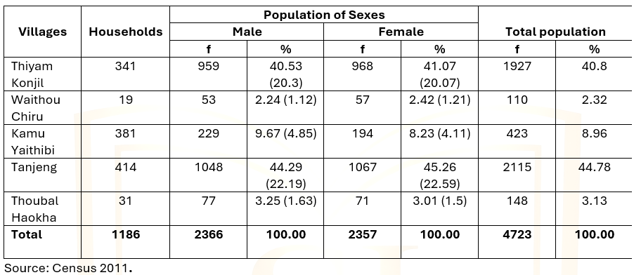
Table 1 provides a brief outline of the population statistics in few of the villages located around the wetland. The male-female ratio in these villages is more or less uniform, with population fluctuation between villages located in the plains (e.g. Thiyam Konjil, Tanjeng, Yaithibi) and those located in the uplands (e.g. Waithou Chiru).
Table 1. Population in Few Select Villages in the Peripheral areas of Waithou Pat
2. REVIEW OF LITERATURE
Rajesh and Devi (2011) reported that the women in the peripheral villages of Waithou Pat wetland harvested aquatic food plants like water chestnut, fox nuts, lotus fruits and roots from the wetland for sale at Waithou Bazar.
Food plants harvested from the wetland and the fish catch from both capture and culture fishery fetches income for the local villagers (Rajesh and Devi, 2011).
Vishwanath (2000) noted that migratory fishes like Bangana devdevi and Labeo bata are favoured food fishes for the people in Manipur. These migratory fishes, which moved upstream from the Chindwin-Irrawaddy river system in western Myanmar via Manipur River and Thoubal River, used to spawn in Waithou Pat in the earlier days. Manipur River is a major tributary of the Chindwin River.
Devi (1993) in her study noted six sectors each of which was dominated by particular aquatic plant species, such as, sector dominated by Pontederia (Eichhornia) crassipes, by Nelumbo nucifera, by Trapa natans, by a mix of Pontederia and Nelumbo, and by Pontederia-Cyprus growths. Some other aquatic plants observed in the wetland are Nympheae pubescence and Nymphoides indicum.
3. METHODOLOGY
The study was primarily undertaken with field visits in different time periods to understand the human population dynamics and their dependence upon the resources of the wetland, along with understanding the changes in the wetland’s ecology and environment in these past several years. Interactive sessions with local villagers in select locations formed the main basis of the information sourced from the ground. The study is supported with information from secondary literature sources.
4. RESULT AND DISCUSSIONS
In the earlier days, locals earned their livelihoods from capture fishery where migratory fish species like Bangana devdevi [1] and Labeo bata were abundant in the wetland during the migration season. These are preferred food fishes for the larger population in the State.
Owing to blockage of the Ningthibi water channel after a weir was constructed at the Cheksabi locality to store water in the wetland (Devi, 1993), the migratory fish species stopped coming here altogether. This considerably reduced the earning capability of the local villagers (Rajesh and Devi, 2011).
The construction of the man-made structure Ithai Barrage over Manipur River near Ithai Khunou village in Bishnupur District obstructed the passage of the migratory fishes from moving upstream.
In the pre-barrage era, the migratory fishes moved upstream up to Waithou Pat wetland to spawn. Thoubal River which is associated with Waithou Pat is a major tributary of the Manipur River. The migratory fishes moved their way upstream to the wetland via the Thoubal River.
Rajesh and Devi (2011) reported that whenever the Thoubal River over-flowed during the monsoons, the in-flowing water usually flooded the wetland, resulting in crop loss in the peripheral shoreline. Fish culture farms, too, suffered extensive loss when there is rise in the water level of the wetland due to the flooding by the in-flowing water from the Thoubal River.
Human ingression into the wetland areas in the form of reclamation for agriculture by draining out the water is gradually affecting the area size of the wetland. Development activities for public water supply scheme and the construction of embankment for government-controlled fishery within the wetland are also affecting the wetland’s overall physical structure and ecology (Rajesh and Devi, 2011).
A study by the Environment & Ecology Office, Government of Manipur (Envis Newsletter Vol.5 (4)) noted that the geophytic phytoclimate of the wetland revealed the advanced successional stage of the vegetation reaching almost the swamp stage.
The study further noted that the hydro-chemical analysis data (2001-2008) indicated that the wetland’s water is highly eutrophic. Devi (1993) also noted that the cultural eutrophication had become a potent factor for the degradation of the wetland.
The SERM (2006) stressed that due to increased toxicity in water, the concentration of dissolved oxygen had decreased considerably and this could be a factor for the decline in fish population in the wetland.
The report further stressed that owing to domestic use of the water of the wetland with high toxicity contain, local villagers are known to suffer from skin diseases.
Although agriculturists by tradition, declining resources sourced from the wetland had forced many of the local population to work outside of their villages in towns and other urban areas.
Men work as rickshaw-pullers in Imphal city and in Thoubal town. They also work as labourers in stone-crushing units, as masons, and as hired drivers for commercial transport carriers. Youths ply commercial vans to earn their livelihood (Rajesh and Devi, 2011).
Table 2. Occupational Status of the Population in Few Select Villages
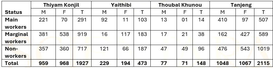
From Table 2 it is inferred that most of the main workers in the peripheral villages are men while the women accounts for lesser number of the main workers. However, in the selected villages of study it was observed that the women outnumbered the men in the marginal workers category, with slightly similar trait in the non-workers category.
5. CONCLUSION
Waithou Pat wetland had undergone considerable physical changes during these past years, mostly owing to human interferences. A large part of the wetland had been reclaimed for agriculture, farms and aquaculture (Rajesh and Devi, 2011).
A major portion of its catchment had been cleared of the greenery for horticultural plantation, mostly pineapple crops. A large part of the hillslopes had been cleared and converted for terrace farming (Rajesh and Devi, 2011).
In part, the reservation of a large part of the wetland in its central zone for state-controlled fishery and water storage for public water supply had further restricted locals from sourcing food from the wetland, thus reducing their earning capability from capture fishery and harvest of aquatic food plants as in the earlier days.
Local informants Ningthoujam Khamba and Thiyam Kondum from Thiyam Konjil village informed that in 1972 a large portion of the wetland was reserved by the State Fishery Department for government-controlled fishery. This prevented the local villagers from venturing into the ‘reserved area’ for their traditional capture fishery and sourcing of aquatic food plants, thus reducing their earning capability (Rajesh and Devi, 2011).
The National Environment Policy (2006) urged for setting up legally enforceable regulatory for identified valuable wetlands and to prevent their degradation, while enhancing their conservation, and also called for taking up explicit accounts of impacts on wetlands by developmental projects, where in particular the reduction in economic value of wetland environmental services must be explicitly factored into cost-benefit analyses.
The NEP 2006 aptly sums up the issue by stating that, ‘The dominant theme of this policy is that while conservation of environmental resources is necessary to secure livelihoods and well-being of all, the most secure basis for conservation is to ensure that people dependent on particular resources obtain better livelihoods from the fact of conservation, than from degradation of the resource’..
Competing interests: The authors declare no competing interests.
Notes
1. Bangana devdevi, locally known as Khabag, a good food fish and highly relished by the locals, migrated upstream from the Chindwin-Irrawaddy river system in Myanmar. The fish swam upstream along the Manipur River and reached the Waithou Pat via the Thoubal River, a main tributary of the Manipur River. When the Ithai Barrage was commissioned in 1983, it blocked the traditional passage of the fish, thus reducing its presence upstream of the barrage. The loss of this fish species affected the livelihoods and earning capability of hundreds of families dependent on capture fishery for their living.
REFERENCES
a) Primary source of information
- M. Sakhitombi Devi, Waithou Tronglaobi.
- Wangkhem Bimola Devi, Waithou Tronglaobi.
- Thiyam Kondum, Thiyam Konjil.
- Ningthoujam Khamba, Thiyam Konjil.
- Thiyam Nipamacha, Saijin Paleb.
- Machingthoi Chiru, Waithou Chiru.
- K. Solomon, Phunan Maring Khunjao Makha Leikai.
b) Secondary source of information
- Devi, Okram Ibeton (1993). Distribution, Primary Production and Nutrient Status of the Macrophytic communities in Waithou lake, Manipur (Unpublished thesis), Manipur University.
- Envis Centre Manipur Newsletter, Vol.5 (4) (2008). Environment & Ecology Wing, Government of Manipur.
- National Environment Policy, 2006. Ministry of Environment, Forest and Climate Change, Government of India.
- Rajesh, Salam and Devi, Kshetrimayum Vedmani (2011). A Study on the Socio-economic status of the local population residing in peripheral areas of Waithou Pat with particular reference to impacts on the wetland, Environment & Ecology Office, Government of Manipur (Unpublished report).
- Report on Landuse Survey Project of Manipur (1990). Manipur State Remote Sensing Centre, Imphal.
- Report on Loktak Notified Wetland, Manipur using Remote Sensing (1997). Manipur State Remote Sensing Centre, Imphal, and Space Application Centre (ISRO), Ahmedabad.
- Singh, H.Tombi and Singh, R.K.Shyamananda (1994). Ramsar Sites of India: Loktak Lake, WWF-India, New Delhi.
- State of Environment Report Manipur (2006), Environment & Ecology Office, Government of Manipur.
- Vishwanath, W. (2000). Fish Fauna of Manipur, Manipur Association for Science & Society, Imphal.